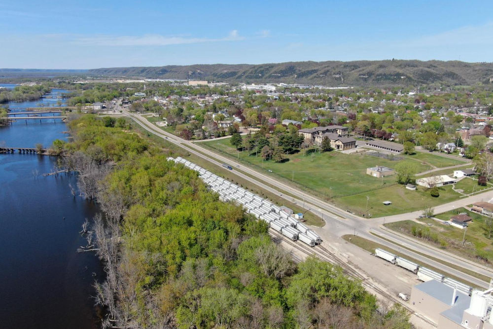
Located within the Driftless Region, Wyalusing Commons is next to some of the most important migratory paths for a variety of birds, fishing and hunting close by, and recreational opportunities range from speed boating to kayaking, biking, fishing, soaring, hiking, and more.
Planned carefully this is within reach at Wyalusing Commons within a special environment appealing to young and older alike.


Q & A about the property: Interview with Ted Pennekamp March 2022
Development of Wyalusing Commons–Phase 1, 2, 3
What is the zoning for the parcel?
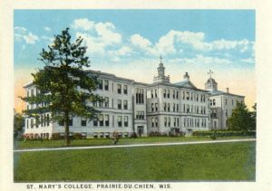
The zoning for the entire parcel is Multi Family and has been for many years. In the 1880s, St Mary’s was operating at the site with a school and housing. In 1969, Clinicare Corp. opened its doors and operated as housing until RVI became owner in 2014.
Will the housing in your plan be condos, apartment building(s), single family houses, or a combination?
Our revised plan(s) show alternate ways of approaching development, and in all cases that involves the smallest developed footprint possible, balancing the need for affordable middle class housing, green space, and preservation areas, with the best outcome for aesthetics and cohesiveness on the site. Our goal continues to be a good neighbor and steward for the Wyalusing Commons site within the community of Prairie du Chien, while creating affordable middle class housing.
What services and types of housing are you proposing?
Our goals are as follows:
PHASE 1–(Completed): Provide a strategy for saving the historic Lawler Lofts building and provide affordable middle class housing for the community of Prairie du Chien by partnering in the plan with Commonwealth Development.
PHASE 2: The Lofts Annex: Provide new construction of attractive apartment buildings that blend with existing buildings in an attractive manner to provide additional affordable middle class housing. Consider dedicated open space to allow for retention of the grotto area and trees, and minimal new disturbance on the upper level, the Southeast corner.
PHASE 3: Provide mixed use housing and professional service space.
We do think that providing neighborhood services and space for some professional offices, salons, or a small cafe in a mixed use configuration on the Northwest corner does make sense. However, that is Phase 3. It isn’t just about services and housing however, it is about context, and I think it is important that charging stations are included, walking trails throughout, beautiful open space is provided, and dedicating space to the beautiful trees (and adding new ones over time) in the center of the parcel is important and a goal. We want to continue to shelter the grotto and provide habitat to an abundant gathering site for Monarch butterflies and birds that congregate there.
The biggest issue is open space–which has rights, and responsibilities, to the owner. We are open to some land donation, but the parcel is zoned multi family and is developable. The idea is to not have an attractive nuisance in the neighborhood, and find ways to protect what we do transfer into open space, to a place that remains free from further development.
So, who will own it, use it, and maintain it, protect it, pay taxes, and insure it is still up for discussion.
I don’t know what the requirements of the Historic District are, the commission, the ordinance, etc. Was a new ordinance passed regarding this type of property?
I reached out to City staff last fall to discuss in a collaborative fashion, how the property could best be developed. Perhaps given COV-19 issues, I did not hear back in 2021. I was informed on February 13th that a Historic District had been overlaid onto our property–without prior notice–which was concerning. I did attend the Historic Commission meeting on March 16th to gain further information regarding the ordinance and to express the desire to collaboratively find a solution for the property.
In general, I am supportive of guidance that will help the City develop in positive ways, which helps land owners do the right thing for the community’s shared enjoyment and economic prosperity, but I also believe that development is important to the City to keep taxes in check as much as possible, and to provide much needed housing.
This is a very important site to us, and has been for many years to many generations and cultures.. So far, I am proud of what River to Valley Initiatives (RVI) was able to do to prevent the loss of the historic building, and what is now Lawler Lofts, and our efforts to have it placed on the Historic Register with an adaptive reuse strategy. I hope acknowledgement of native persons to the area will be made, as well as other historical time markers.
What was the alternative to RVI’s ownership?
What is crucial to remember is that the very real alternative for the entire site was demolition, or decay and vandalism of an empty building until it was demolished. All this would have been an additional burden to the City, and the eventual sale does not necessarily mean an attractive neighborhood would have been built. Clinicare did not want that sad ending, and neither did RVI. Long ago, prior to St. Mary’s, it was originally intended for single family housing. St Mary’s began the transition to a multi family site, then Clinicare, and it still makes sense as multi family today. Maintenance costs for such a large site are significant. In my worst dreams, I can also envision that the trees would have likely been harvested, the buildings removed, and who knows what would have occurred on the site overall.
None of this happened, of course, but even without a Historic Commission, we cared enough to work on this particular project to work on Phase 1, and many ideas for the remaining areas are in discussion. We want to develop appropriately. We had no control of course, when across the Main Street, well within view near the river, the RR and frac sand station was allowed and in place, which is unfortunate from a community viewshed standpoint so near downtown and the center part of the City. We believe our buildings will be assets and attractive to the community.
What is the reasoning for developing it at all?
First of all, there are holding costs and ongoing costs to land ownership that accumulate and are ongoing for any owner. There are liabilities to allowing access from the general public on someone’s private land, and for many years, permission by St Mary’s, I assume, and Clinicare, and throughout our ownership, was granted for limited access on the property. To do otherwise invites the issue of becoming “an attractive nuisance”, so we have been careful in granting access.
What does RVI do?
Our business is that of in-fill development for rural communities for the benefit of communities, and that is challenging work. Prairie du Chien has already benefited from that work over the years, in addition to Lawler Lofts. It is also important to remember that Clinicare, who had occupied the site since 1969, was a good neighbor, and wanted to work with us to save the building and grounds. Commonwealth Development, who we brought to the project, did a fantastic job as well, and all units were immediately occupied upon completion in 2018, and have been so since.
That preservation and adaptive re-use effort has resulted in not only preserving a monumental 80,000sf historic building, thereby contributing to the historic nature in Prairie du Chien, it also meant a development investment value of over $13 million into the City at that time..
What potential investment into the City remains for this land?
I expect Phase 2 will be just under $10 million, and Phase 3 about $6 million in development costs. Overall, a huge input in value to the community, not only in taxes, but also attractive housing.
How will you incorporate some community access land? As a possible park?
I think the best developments incorporate green space, naturalized (though managed) areas for habitat for pollinators, and planting trees to help incorporate old, and new buildings to soften the hard edges of the built structure and any parking.
As for a park, I don’t think we need more playground equipment as much as a bit more open space to play and to enjoy. Threading the proverbial needle to balance costs, ongoing management, land ownership rights and responsibilities, community enjoyment ,and allowing for an appreciation of the full picture of history and our natural environment is important to truly do a great job when developing any neighborhood.
My private sector career has been about developing and approving appropriate design and architectural guidance and neighborhood development, so I feel confident that we can develop a beautiful space with beautiful appropriately designed buildings that adhere to what guidelines the Historic Commission would like to see. There is also a cost component in this very volatile building market, but we think it is doable.
When the property sells, what would the new owner have to do regarding their plans and the Native American Mounds? Where are the Native American Mounds on the property?
I am not aware of “mounds” per se left on the former Fort Crawford site, but I am aware of the State of Wisconsin’s historic overlay on the upper level Southeast corner of the property, which has to do with some foundations still in place, and the potential for a burial area during that time period of the Fort, specifically most likely near a tree on the upper area–but that is not for sure, even at this point. In general, I would prefer that this upper area not be disturbed further–it was significantly disturbed in the 1930s I believe, and also when the Beaumont Ave improvements were done.
I think the best option to achieve the goals I have stated is to work collaboratively with all parties to do our best, and finalize the sale, which is in process.. 2020 and 2021 slowed this all down, but at this point we are preparing for sale and development of Phase 2, and I hope to have more input from the Planning Commission as well to finalize the layout so we can proceed with necessary development materials for final approval. I am confident that we can meet the specified standards of buildings currently outlined by the Historic Commission regarding the structural aesthetics..
The State provides for development, but with supervision by an organization such as the Mississippi Valley Archaeology Center. They have been involved in this site for decades. That process was done when the Lawler Lofts garages were built, (nothing was found to my knowledge). This process also would be done when the foundations to former (removed above ground already) Clinicare garages and possibly the former tennis court would be removed. We have allowed basketball court usage on that court, and it would be great if there was some way to continue that. In conversation with the Historic Commission on the 16th, it was acknowledged that these (garages and Tennis Court) areas were already significantly compromised, so there was not much opposition to development on those formerly already disturbed sites opposite the new garages. That is why we show this possibility in CONCEPT B..
The balance of the land is not considered an important Historic site by the state, and does not require excavation supervision by organizations such as the Mississippi Valley Archaeology Commission. That said, I think it is important to understand the impact of Fort Crawford on the Native American population as well. It is my hope that developing sensitively going forward will help in that end, and more site markers will tell that full story of long ago, and also recent history in preservation.
I believe the Monarch Gardens area preservation, along with minimal disturbance on the Southeast corner will be a step in the right direction.
How much is RVI asking for the property?
We need to finalize our layout. The entire parcel is appraised between $800K to around $1.2 million. Donated green space significantly reduces that calculation, so that is not a sure thing at this point and further discussion and thought is needed at this time.
Could the property be possibly sold in parts, to different owners, rather than all at once?
There are now 4 lots established, each with benefits and features that are unique to various owners.
Is RVI a non-profit?
RVI is a non-profit.
.
Will part of the property be preserved? Some parts are nice looking. I suppose that will be up to the new owner(s).
I hope there will be a way to preserve open space, and that will come down to who ultimately will manage and own it in the way intended. We need conversation on this with the City to proceed–because any donated land will need to be donated to an entity that can manage it properly.
We have two conceptual drawings that I believe will help visualize the potential. These are not final, but given a sense of size and location, along with potential benefits.
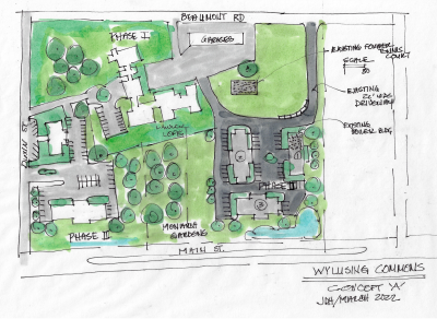 CONCEPT A: indicates buildings built on the Southwest corner of the property, down the slope, to minimize site line intrusion, and open up the view to the main building of the historic Lawler Lofts. This allows for a large undeveloped Southeast area, and expanded grassy area adjacent to the Monarch Gardens.
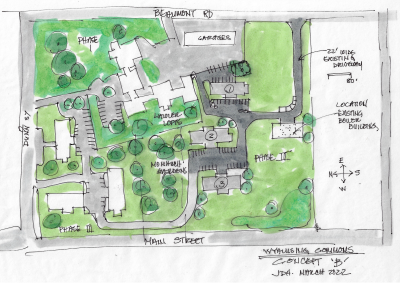 CONCEPT B: indicates building down the slope and on the former garages (already disturbed land) and tennis court, and down the slope. This provides for a continuous grassy area on the south of the property. Again, the next steps for the boiler building are in question. It could be adapted for housing or other purposes, torn down and something else rebuilt on site, etc.
We revised original concepts with feedback we have obtained so far. We have maintained access to Beaumont on the south end, essentially where a driveway is already in place, and would only require resurfacing, not disturbance.
Each of these drawings depict minimal view impact from Beaumont Ave, as the slope comes into play. Concept B opens up the view on the south, Concept A opens up the view of the historic Lawler Lofts and greens spaces.
We could allow for non disturbance of the grassy areas where the State indicates Historical prominence, and allow for the preservation of the Monarch garden area along with potential community access and open space. I think these plans address concerns about aesthetics, views for the majority of community members, access, preservation, environmental sensitivity, and housing.
–Julia Henley, President, River to Valley Initiatives, March 27, 2022
This 8.19-acre property fronts the bypass and has views of the great Mississippi River. The property is for sale at the price of $1.2m. Attractive investor participation options are also available.
Tourism Mecca, Healthy Local Industries, Small Town Living
The area tourism spending of over $10 Million lends the business proposition of a successful residential stay, special event and spa development as the first right hand turn from Iowa. The traffic counts are good, and a business could build on area economics.
Healthy Local Infrastructure, Prime Location ready for Mixed Use
Development partners and investors are possible for this incredible opportunity for the creation of something new–a mid size rural city that is like no other, and embraces the best of the future, the past, rural, small town and well served communities–hospital, theatre, airport, and a convenient location.
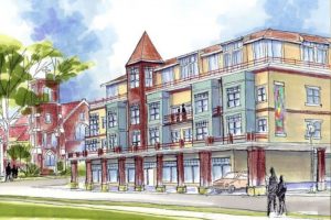 The rendering shows many possibilities, but final plans and property uses have not been established.
In this age of technology marrying environmental awareness, embracing a new way to develop a sustainable community is possible at this site.
Local recreational and local biking and walking, connections, gardens, and hospitality –just a few of the possibilities in this incredible opportunity for the visionary developer.
With thoughtful development, Wyalusing Commons will be a destination of neighborly interaction, comfort, beauty, and a new chapter in this growing river town. Join us.
Historic Community, Prime Location
Prairie du Chien has been for almost two hundred years, a place of starting anew, forging ahead, evolving, and changing with the times. Stunningly prime location featuring eight plus acres facing west, overlooking the Mighty Mississippi provide a regional and local opportunity. This exciting location can be a notable first step in the next chapter for small city development in the heart of the Driftless Region’s Midwest.
For qualified developers and investors in the properties’ parceled or planned development, there are public/private partnership opportunities. Depending on what the specific plan is for the acreage–strategies can offset development costs to achieve shared desired results.
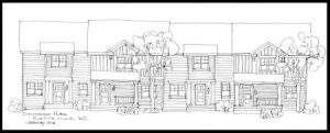
Photos and drawings shown are just a few concepts at this time.
![]()
Contact Julia at jdhenley11@gmail.com
Contact JD Milburn at jdmilburn50@gmail.com

